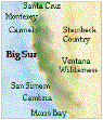
Big
Sur EcoGuide
Big
Sur Camping
Birding
Song
Bird Banding
with
Ventana Wilderness Society
Hiking
Lodging
Interactive
Map
Story
of Big Sur
Old
Coast
Road
& Hwy One
People
& Places
Bixby
Bridge
Molera
Beach
Partington
Cove & Canyon
Julia
Pfeiffer Burns State Park
Nacimiento
Road
Ventana
Wilderness
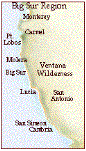
Big
Sur Lodge

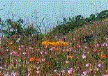
Wild
Iris in Big Sur
Carmel
Lodging
Santa
Lucia Reserve
Mission
San Antonio

Chaparral Sweet
Pea
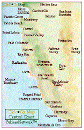
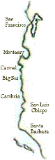
Central
Coast Interactive Map
Monterey
Bay Volunteer

Monterey
Pacific
Grove
Monarchs
in Pacific Grove
Pebble
Beach
Carmel
Carmel
Valley
Point
Lobos
Monterey
Peninsula
Wildlife
in San Simeon
|
Once
thought extinct, Elephant Seals have made a
resounding comeback. Go to the scene of some
real wildlife excitement. Hearst would have
loved it, right there in his front
yard!
|

Fremontia
Cambria
Cayucos
Harmony
Morro
Bay
Montaña
de Oro
Pinnacles
Monument
Salinan
Nation
Steinbeck
Center
Central
Coast Activities
Santa
Cruz
Natural
Bridges Butterfly Sanctuary
Castroville
Artichokes
Santa
Cruz Redwoods
Marine
Sanctuary
Moss
Landing
Voices
of the Wetlands
Elkhorn
Slough
Pelican
Protection Alliance
California
Back Country
San
Juan Bautista

PelicanNetwork
About
Pelican
Pelican
Membership
Member’s
Comments
PelicanNetwork
Links
Other Big Sur
Websites
Ventana
Wilderness Alliance
VWA
Double Cone Quarterly
Henry
Miller Library
Big
Creek Reserve
Esalen
Institute
Ventana
Wilderness Society
Condors
Robinson
Jeffers
Camaldolese
Hermitage
Nepenthe
Big
Sur Land Trust
Interactive map
|
California
Central Coast
EcoGuide
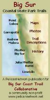
Big
Sur Hiking Trails
|

|
|
|
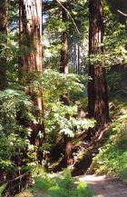
Good
trails and spectacular country. Not as
high, but steeper than the Sierra, and
more diverse. Big Sur and the Ventana
Wilderness offers challenges. The broad
biodiversity, newborn geology, and the
closeness of the ocean combine to
assault the senses in unexpected
ways.
|
|
|
Our
first featured hike is a pleasing
encounter for Big Sur veterans, and
first timers. Partington
Cove, Creek and
Canyon
offers a great sampling of the
incredible Big Sur Country, and ranges
in difficulty from easy to a little
more than moderate. So, we’re in Big
Sur. Let’s
Hike!
|
|
|
Our
second featured hike is also in Julia
Pfeiffer Burns State Park. Click this
link to go to the Ewoldsen
Trail
|
New
Condor Photos
|
Partington
Cove and
Partington
Canyon
Trail
access is 36 miles south of Carmel
11 miles south of Big Sur
8 miles south of Nepenthe
1.8 miles north of the entrance to Julia
Pfeiffer Burns State Park
|
|

Top
of the trail – look out from Ewoldson
|
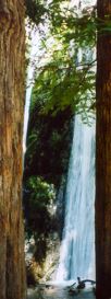
Short Hike to
the Cove
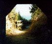
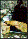
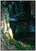
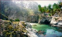
Partington Cove
on the south side of the point, trail from the
tunnel.
|
Partington
has two great hikes. First is a two mile loop
to the ocean. It begins at an iron gate along
Hwy One.
It is a fine trail down to the beach, but
steep. The trail goes down to the
Partington’s graceful little exit to the
Pacific Ocean. then you back track up the
creek to a bridge (there’s an outhouse
nearby). Over the bridge you come upon a 100
foot tunnel to Partington Cove. This is like
Fantasy Island. but, better, as this is real.
Mules used to haul wagons of tanbark through
here.
The picturesque little cove is home to sea
otters and seals, very clear waters and a
kelp forest. It is a wildly aquatic
experience. On the point is an old hoist
stanchion, used for loading cargo, lumber and
tanning bark. The iron eyes for tying up the
ships are still in place. You can imagine
pirates and bootleggers rousting about.
|
|
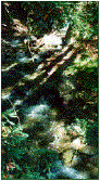
Partington
Creek comes down through the canyon as a
rushing, wild river, then dips under Hwy One
through a man made tunnel.
On the other side it enters another natural
state.
|
|
Partington
Creek comes down through the canyon as a
rushing, wild river, then dips under Highway
One through a man made tunnel. On the other
side it enters another natural state.
|
Then, as a bucolic
brook, it babbles down to granite pools where
it lazes around in a whirl, then tumbles out
onto the rocky beach and into the
ocean.
|
|
Long
Hike up the canyon
|
|
|
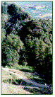
The
second Partington hike begins on the east side
of the road. Bring a flashlight and canteen. For
the first third of the trail there is plenty of
good fresh water. No so, later.
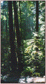
Initially, the trail can be confusing. If you
start out going to the left of the creek, you
will have a lovely saunter in the redwoods, and
come upon an idyllic picnic spot –a boulder
hanging over a wide sparkling pool, with a
waterfall in a cathedral of Sequoia
Sempervirens. But, this is the wrong trail. It
dead ends at a cliff.
|
|
The
real trail, the Tanbark, goes along the south
side of Partington, and then up. It branches to
the left in three spots, leading into forests
deeper into the canyon. It stays right,
ascending the canyon. there are a few signs. The
Old Coast Trail crossed here, and surely the
ghost of Robinson Jeffers is about.
In several places, particularly in the Swiss
Camp area, you see arduous stonework made 70
years ago.
|
|
|
Gunder
Bergstrom, who lived here in the 1920s, did the
work, and it shows a deep love for the area. The
stone bridge he built is like a little human
cameo to accent a wish to preserve one of
nature’s finest settings. The bridge allows the
place to be appreciated without offending it by
tramping it.
|
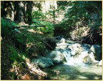
You
cross streams and pass springs that bubble up
in fern groves, and out of the sides of the
canyon. The trail switches back into
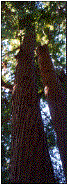
sycamore, then tanbark oak and into unusual
old growth redwoods.
The McLaughlin Memorial Grove, on a ledge,
in a nook of the forest, high above the
raucous creek, is awesome. The Grove is home
to redwoods with spiraling bark.
|
|
|
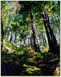
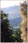
The
trail hugs the canyon slope in a chaparral
studded with venerable Madrones and Manzanitas
and piercing views of the sea, across to
Partington Ridge, and up into the Santa Lucias.
You ascend on a moderately steep gradient, about
12 to 14%. Continuing up until you are 2,000
feet above the ocean, and can see it through
redwoods. It looks like another planet. On
summer afternoons you can watch huge fog banks
flow toward the shore far beneath.
|
|
Near
the top you encounter a well graded road. This
can be your return trip. It is considerably
shorter, descending to Hwy One about
three-quarters of a mile south of the point you
started. So, you will have to hike up the
highway to get back to your car.
At the top you feel you are at the top of the
world. From here the coastal views are sweeping
and the sea is endless. The view east is to the
Santa Lucia high country.
|
|
|
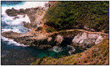
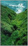
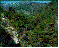
Partington
Canyon ridges tower thousands of feet above
the Pacific. In the distance are Ventana
Cones, each nearly 5,000 ft.
|
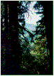
Along
the trail are glimpses of the great Pacific.
To look at the ocean, practically straight
above it by a couple of thousand feet, while
in a redwood forest is a rare experience.
|
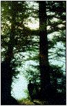
Photo by
Margie Whitnah
|
|
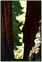
You
find the Tin House at the top. It was built by
Lathrop Brown, who lived in the grand home
across the cove from McWay Falls. Brown was a
high official in the U.S. State Department
during Franklin D. Roosevelt’s presidency.
Oddly, the house up here was built of tin
salvaged from gas stations before World War Two.
Its design is weird, too. Even though it is
situated atop a 2,000 foot mountain, practically
on top of the ocean, with majestic views, it has
no view from inside the house to the west.
More
about the Tin House and the Browns
|
|
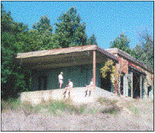
The Tin House at the top of the Partington
Canyon Hike
Photo by Stuart and Julie
Stair
|
|
Caution:
Do not take this hike late in the day. At a
moderate speed, with stopping, it is a 5 hour
hike. If you return by the same trail, it will
be longer.
If you
descend by the fire road, it will be faster.
But, the fire road down the mountain is very
steep, dark and winding. It is not good to get
caught there in the dark. You will hear sounds
that may cause you to question your sanity for
having started the hike too late in the day.
|
|
|
|
|
|
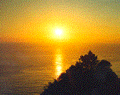
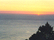
Partington
sunsets can be outrageous and sublime. They
should be enjoyed after you have hiked back down
from the mountain. Hiking back down Partington
Canyon in the dark can test one’s nerves. These
shots were taken at Partington Point close to
the highway. Big Sur sunsets are nearly always
great October through December.
|
|
Have
a great hike, and please, leave no
trace. Whatever you bring in, bring
back out.
|
|
|
If you want updates about Big
Sur and the Central Coast, join the
PelicanNetwork email list
|
|
|