Big
Sur Lodge

Big
Sur EcoGuide

Big
Sur Camping
Birding
New
Condor Photos
Hiking
Lodging
Song
Bird Banding
with
Ventana Wilderness Society
Interactive
Map
Big
Sur
Chanterelle
Cook-Off
Story
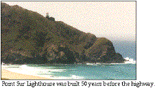
of Big Sur
Old
Coast
Road
& Hwy One
People
& Places
Bixby
Bridge
Molera
Beach
Partington
Cove & Canyon
Julia
Pfeiffer Burns State Park
Nacimiento
Road
Ventana
Wilderness
Big
Sur Lodge

Wild
Iris in Big Sur
Carmel
Lodging
Santa
Lucia Reserve
Mission
San Antonio

Chaparral Sweet
Pea
Central
Coast Interactive Map
Monterey
Bay Volunteer
Monterey
Pacific
Grove
Monarchs
in Pacific Grove
Pebble
Beach
Carmel
Carmel
Valley
Point
Lobos
Monterey
Peninsula
Wildlife
in San Simeon
|
Once
thought extinct, Elephant Seals have made a
resounding comeback. Go to the scene of some real
wildlife excitement. Hearst would have loved it,
right there in his front yard!
|

Fremontia
Cambria
Cayucos
Harmony
Morro
Bay
Montaña
de Oro
Pinnacles
Monument
Salinan
Nation
Steinbeck
Center
Central
Coast Activities
Santa
Cruz
Natural
Bridges Butterfly Sanctuary
Castroville
Artichokes
Santa
Cruz Redwoods
Marine
Sanctuary
Moss
Landing
Voices
of the Wetlands
Elkhorn
Slough
Pelican
Protection Alliance
California
Back Country
San
Juan Bautista

PelicanNetwork
About
Pelican
Pelican
Membership
Member’s
Comments
PelicanNetwork
Links
Ventana
Wilderness Alliance
VWA
Double Cone Quarterly
Henry
Miller Library
Big
Creek Reserve
Esalen
Institute
Ventana
Wilderness Society
Condors
Robinson
Jeffers
Camaldolese
Hermitage
Nepenthe
Big
Sur Land Trust
Interactive map
|
Big Sur Introduction and
Story
Eco
Guide to California Central
Coast
|
Big
Sur
appears
smooth, seductive
Yet
seems forbidding, distant, and
haunting.
|
|

|
|
|
The
fearless, intrepid Spaniards called it
“The great country to the South” – and
they were leery of venturing
there.
These
lands remain elusive to most Caucasians,
but to Indians this was a pleasing
place.
|
|
|
Before
a white person ever saw Big Sur, a large
population of Indians lived here
peacefully and prosperously for thousands
of years. Salinan, Esselen, and
Ohlone-Rumsen artifacts show Big Sur
habitation for 10,000 years.
In
1542 Cabrillo sailed by here and wrote:
“There are mountains which seem to reach
to the heavens, and the sea beats on
them.”
|
|
|
|
Big
Sur began 35 million years ago, 14 miles deep in
the earth off the coast of Mexico. Tectonic plates
rubbing against each other moved these mountainous
rocks north. Five million years ago they pushed up
out of the ocean to form an island that is now Big
Sur. The Santa Lucia range, which includes the
Ventana Wilderness of today, is young and
precocioous.
|
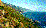
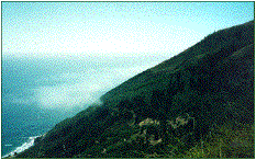
Today,
Big Sur is a coastal wilderness. It is as raw as
could be imagined for its 200,000 acres and 90
miles of California coast. It is a grand
testimony to the human craving for appreciating
this undeveloped, natural beauty that it has
been protected. A highway was constructed in the
1930’s just to see this boldly beautiful natural
setting. The road in this setting has come to
define Big Sur for most people. But, the will of
the pioneers to conserve the remarkable region
has prevented its destruction by development.
Ninety-five per cent of
Big Sur is the fold-upon-fold of Ventana
Wilderness, rare biology, incredible geology
that most people do not ever see. In the coastal
mountain canyons that vein the intricate quilt
of watersheds (e.g. a hike in Partington) one
gets an inside peek at this wondrous
country.
In these pages you will
come to know it, want to appreciate it and help
conserve it.
|
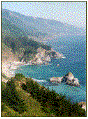
|
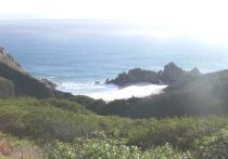
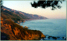
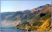
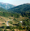
Big
Sur Coast from high up Partington
Canyon.
Photo
by Margie Whitnah
Click
the photo for a larger version.
|
|
|
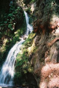
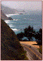
Around
a bend in the Big Sur road, about seven
miles south of Nepenthe, the McWay
waterfall suddenly appears. In
mid-formation is Saddle Rock, an object of
wonder for Big Sur pioneers.
|
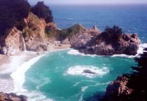
Click the image for a larger version
|
Julia
Pfeiffer Burns State Park
begins here. Julia was a pioneer, and the park was
named after her by Helen and Lathrop Brown. Lathrop
was a congressman from New York, and became a high
ranking official in the U.S. Dept. of Interior.
Helen was the daughter of a wealthy banking family.
Together they built resorts on the Eastern
Seaboard. They researched to find what would be the
perfect seaside location on the Pacific Ocean side
of the continent. After coming to Big Sur, they
found McWay Cove, bought it, and built the
Waterfall House.
They so admired their
caretaker, Julia Pfeiffer Burns, the Browns
bequeathed the land to California for a
park.
Called “Saddle Rock Ranch”
by the Browns, the property reaches north to
Partington Cove, and east to the ridge where they
built the Tin House.
Read about the
Browns
|
McWay
Falls used to drop directly into the ocean.
In 1983, however, the California Department
of Transportation, while repairing Hwy 1 from
landslide damage, bulldozed earth into the
ocean, creating more beaches.
The
cliffs are rugged, and the cove cannot be
reached by foot. These waters offer
spectacular scuba diving,
but only with a permit. The waterfall can be
approached by trail from the park. There’s an
exquisite picnic area in the redwood grove
along the creek, and trails up to the ridge
overlook the coast. Next to the falls are two
hike-in campsites.
|
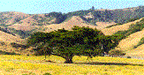
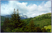
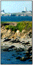
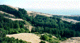
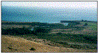
North coast scenes. A grand
oak and Little Sur River.
Photos by Jack
Ellwanger
|
Click photo for larger
version
|
|
|
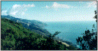
The
“state of mind,” that is this region, is
geographically 90 miles long and 20 miles
wide. Much of the best to see requires
more than driving along the
coast.
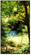
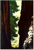
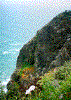
Partington
Canyon,
and its stunning forests, including
ancient growth redwoods, are close to the
highway, but must be hiked to.
To
experience the rarefied atmosphere of a
Big Sur mountain coastal
canyon,
take a hike in
Partington.
|
|
|
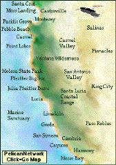
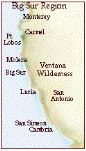
|
Click this
graphic for an interactive map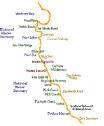
|
|
|
Hwy 1 threatened the majestic serenity of the
Ventana region of the California Central Coast.
People who loved the area feared the worst.
Development would surely be on the heels of the
road, and that would bring ruin to the region.
|
|
As
befits the character of the people who
inhabit this region, like those in
Carmel before them, the people rose to
thwart back the specter.
|

|
|
|
|
Margaret
Owings, resident and conservationist,
said, “There’s something about Big Sur
that puts people in their place.
Something they have to come back to,
because it does something to you. And
it gives you a responsibility to keep
it like this.”
|
|
|
|
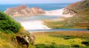
Big
Sur River runs free and wild out of the
Santa Lucia Mountains through Big Sur
Valley and meets the sea in a lagoon at
Molera Point.
|
The
village of Big Sur is demurely
strung along the Redwood-lined road
in the Big Sur Valley south of
Molera.
|
|
|
Some
of the finest novelists, painters, poets and
photographers have found inspiration for their
works in Big Sur’s Coast. Robert Louis Stevenson,
Mary Austin, Jack London, Sinclair Lewis, John
Steinbeck, Robinson Jeffers, Lillian Ross, Jack
Kerouac, Henry Miller, Edward Weston, Ansel Adams
all came here and enriched their palettes.
(See
Big
Sur People and Places)
|
|
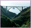
Bixby
Bridge
This
view from the back shows the geological
significance of spanning the canyon. Before the
bridge, this was considered the beginning of Big
Sur. Hardly anyone went beyond this point. A ten
mile inland road accessed the lower reaches of
the coast.
In
the bottom of this canyon, which was called
Rainbow then, there was a resort owned by the
family that rediscovered the Sea Otters in 1938.
Bixby once was a busy place. By 1910 there were
a dozen limekilns operating in the
canyon.
Kerouac’s
last novel, Big Sur, the telling
of man’s ferocious relationship with nature, was
written from three trips to this canyon. He
thought the creek, canyon and beach here made
him insane.
|
|
|
Ending
Big Sur’s isolation in 1932, the 714 ft long Bixby
Bridge made the Carmel – San Simeon road an
accomplishment for the ages. It is constructed of
6,600 cubic yards of concrete and 600,000 pounds of
reinforcing steel – and straight up, 260 feet above
the creek. The concrete abutments, anchored into
sheer rock walls 140 feet above the creek, are 330
feet apart.
Its
graceful arch bows over the creek in the scrubby
canyon that rises abruptly on both sides from the
sea. It is one of the
highest single-span arch bridges in the
world.
On
the
Bridge
A Paper
about Big Sur Bixby Bridge
By Sean
Vitousek
|
|