|
View or download this document in Adobe pdf format (1MB) (When printing the pdf, check
"auto-rotate and center" in your printer’s dialog box.) Note – Images on this page and in the hyperlinked pdf were repaired 10 am, 5/8/08.
(Draft. Subject to Big Sur Community approval.) PROPOSED PROCESS FOR WRITING THE MASTER PLAN
The purpose of this process is to agree on the Master Plan for the portion of the California Coastal Trail that passes through Big Sur (The Trail).[1] AREA The area within which The Trail shall be located shall be from the Pacific Ocean on the west, generally to the eastern boundary of the California Coastal Zone, and from the Carmel River on the north to San Carpoforo Creek in San Luis Obispo County on the south (The Area). For purposes of this document, the "Big Sur Community" shall include all individuals who are residents and/or landowners within The Area. To implement the planning process in this proposal, The Area shall be broken into the planning segments described in Appendix B. ORGANIZATION The following groups are/will be formed to implement this process for writing The Trail Master Plan:
These groups shall have the composition, duties and responsibilities described below.
EXECUTIVE COMMITTEE NAME The name of the executive committee shall be the Executive Committee for the Big Sur Portion of the California Coastal Trail (Executive Committee). EXECUTIVE COMMITTEE PURPOSE The Executive Committee’s mission statement is as follows:
The Executive Committee’s purpose shall be to develop and steward a grassroots, community-based planning process for The Trail by:
EXECUTIVE COMMITTEE MEMBERSHIP Membership of the Executive Committee shall be comprised of the residents and property owners within The Area who responded to the invitation to participate, who have attended trail meetings, and who are listed in Appendix A. Residents and property owners within The Area may petition for removal of any member of the Executive Committee.
LOCAL WORKGROUPS NAME The name of each Local Workgroup shall be The Local Workgroup for Segment [insert segment number (1 to 6)] of the Big Sur Portion of the California Coastal Trail. LOCAL WORKGROUP PURPOSE There shall be one Local Workgroup for each trail segment. Each Local Workgroup shall determine the alignment of The Trail through that Local Workgroup’s segment. Each Local Workgroup shall also determine trail design and attributes for each portion of its segment, and shall also determine the entity that will be responsible for management, maintenance and policing for each portion of its segment. Local Workgroups shall communicate with the Local Workgroups to their immediate north and south (as appropriate) to ensure that the trail alignment for each segment connects with those to the north and south. LOCAL WORKGROUP MEMBERSHIP Each Local Workgroup shall be comprised of individuals who reside and/or own property within the pertinent segment who wish to join and participate. Designated representatives of public agencies that own land or have management responsibility for land within the segment shall be encouraged to participate in Local Workgroup meetings for the segment as a non-voting member of the Local Workgroup. For consistency’s sake, public agencies are encouraged to designate one (and the same) individual to represent the agency for each Local Workgroup for the duration of the Trail Management Plan drafting process. Local Workgroups shall keep minutes of each meeting including a record of motions and decisions. All Local Workgroup meetings shall be open to the public. The intent is to make participation in Local Workgroup meetings as inclusive as possible. LOCAL WORKGROUP REPRESENTATIVES Each Local Workgroup shall vote to decide on one individual to represent the Local Workgroup on the Steering Committee. LOCAL WORKGROUP DECISION-MAKING Local Workgroups should make decisions by consensus to the extent possible. If agreement cannot be reached after reasonable attempts at resolution, members of the Local Workgroup may request that the Executive Committee resolve the disagreement. PUBLIC AGENCY PARTICIPATION ON LOCAL WORKGROUPS Public agency participation shall include, but not be limited to (within the spirit and scope of this proposal), ensuring that trial alignment and design is consistent with all applicable requirements of the pertinent agency. Public agency representatives will facilitate the Trail Master Plan process within the scope of their authority and expertise, subject to the formal approval by the agency.
STEERING COMMITTEE NAME The name of the steering committee shall be The Steering Committee for the Big Sur Portion of the California Coastal Trail (Steering Committee). STEERING COMMITTEE PURPOSE The purpose of the Steering Committee shall be to provide an overview of The Trail planning process undertaken by Local Workgroups. The Steering Committee shall also act as a communication conduit between the Executive Committee and the Local Workgroups. STEERING COMMITTEE MEMBERSHIP Membership of the Steering Committee shall be comprised of five representatives elected by the Executive Committee, plus one representative elected by each Local Workgroup (for a total of 6 Local Workgroup representatives). Individuals who live within or own property within a trail segment may petition the Executive Committee to remove their Local Workgroup representative from the Steering Committee. Should such removal occur, a vote for a replacement representative shall be held by the Local Workgroup.
GUIDELINES FOR THE MASTER PLAN PROCESS GUIDELINES FOR PUBLIC OUTREACH Ongoing outreach shall keep the public and residents and property owners informed of meeting dates and activities of the Local Workgroups, the Steering Committee and the Executive Committee. Interested public agencies shall designate their contacts, who shall be kept similarly informed. The Steering Committee shall be responsible for informing the Executive Committee of meeting dates and other relevant information, and the Executive Committee shall be responsible for communicating the information to the public. All meetings (Local Workgroup, Steering Committee and Executive Committee) shall be open to the public and the public shall be encouraged to contribute to the discussion. GUIDELINES FOR THE TRAIL’S ALIGNMENT
GUIDELINES FOR THE TRAIL MANAGEMENT PLAN’S CONTENT The Trail Management Plan shall include at a minimum:
PROCESS FOR AMENDING THIS DOCUMENT The Executive Committee anticipates that changes to the process described in this document may be needed after the process of writing The Trail Master Plan begins. After adoption of this proposal and its approval by the Big Sur Community, the Executive Committee may amend this document as needed, provided that the amendment is first provided in context to all members of the Executive Committee, and at least one Executive Committee meeting is held at which the amendment is open for discussion. After an amendment is approved by the Executive Committee, it shall not become effective until after the amendment has been approved by the Big Sur Community in a manner comparable to the community’s initial approval.
[1] The executive committee decided this work does not include a “community trail” or other trails. Which is not to say that use of the CCT by the Big Sur Community cannot be considered when choosing The Trail alignment and/or design. [2] About seventy-five percent of the land in Big Sur is currently in public ownership, and the Highway 1 right-of-way spans the entire area. There is sufficient land in public ownership and within existing easements so there is no need to require private landowners to provide for The Trail. Moreover, the CCT advocacy book, Hiking the California Coastal Trail, assumes most of the CCT through Big Sur will be in the Highway 1 right-of-way. [3] This language does not preclude non-profits from helping the agency.
Appendix A
Jack Ellwanger Mary Trotter Betty Withrow Pam Peck Lisa Kleissner Kerri Frangioso Jon and Corrine Handy John Doud Tracy Cheseborough Belinda Shoemaker Lygia Chappellet Mike Caplin Honey Williams Thomas Rettenwender Barbara Woyt
Appendix B
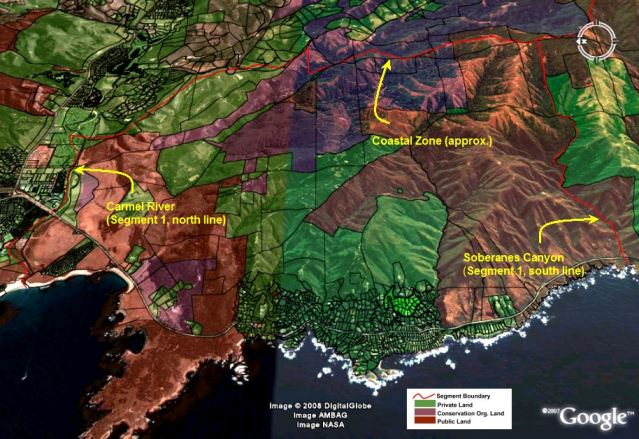
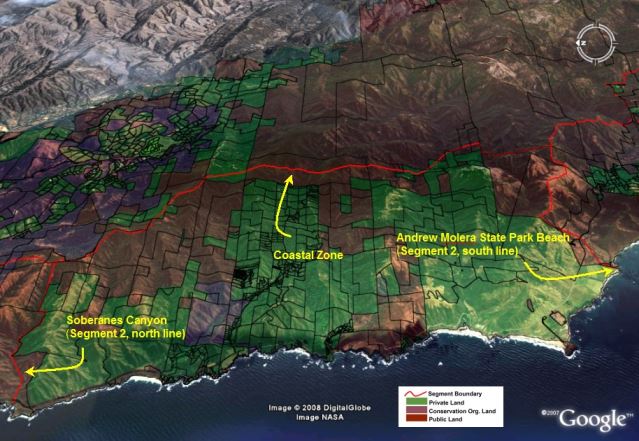
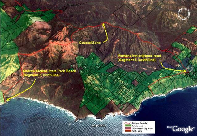
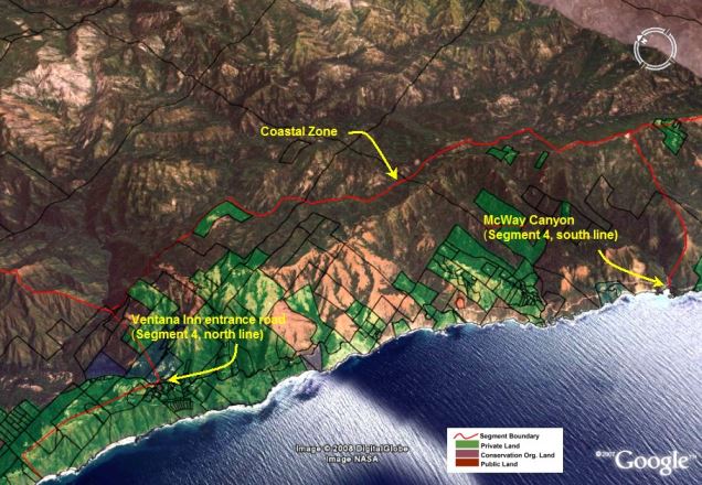
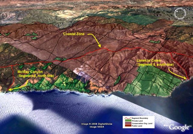
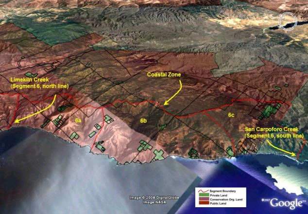
PLANNING-SEGMENT BOUNDARIES The Planning Segments used to define the area within which The Trail shall be planned by each Local Workgroup are generally as follows (note that segment 6 is broken into three subsegments). Local Workgroups may adjust segment boundaries to avoid splitting parcels or ownerships. The eastern boundary for all segments is generally the eastern boundary of the costal zone (areas further east may be included if needed). See the following GoogleEarth images for graphic representation of the approximate location of planning segment boundaries (note that ownerships and lines in images may lack accuracy).
Planning Segment 2 — North boundary is the southern boundary of Planning Segment 1. South boundary is generally to Andrew Molera State Beach Park, including the Andrew Molera State Park main trailhead (post mile marker 51.1, near junction of Old Coast Rd. and Highway 1). This segment is approximately 15 miles north to south. Planning Segment 3 — North boundary is the southern boundary of Planning Segment 2. South boundary is generally Ventana Inn entrance road (post mile marker 44.5 on Highway 1), including the Coast Ridge trialhead. This segment is approximately 7 miles north to south. Planning Segment 4 — North boundary is the southern boundary of Planning Segment 3. South boundary is generally McWay Canyon, including the McWay Canyon trailhead in Julia Pfeiffer Burns State Park (post mile marker 35.8 on Highway 1). This segment is approximately 9 miles north to south. Planning Segment 5 — North boundary is the southern boundary of Planning Segment 4. South boundary is generally Limekiln Creek, including the Limekiln Creek trailhead in Limekiln State Park (post mile marker 21.0 on Highway 1). This segment is approximately 15 miles north to south. Planning Segment 6a — North boundary is the southern boundary of Planning Segment 5. South boundary is generally Pacific Valley/Sand Dollar Beach, including Sand Dollar Beach trailhead (post mile marker 14.0 on Highway 1). This segment is approximately 7 miles north to south. Planning Segment 6b — North boundary is the southern boundary of Planning Segment 6a. South boundary is generally Salmon Creek, including the Salmon Creek/Silver Peak Wilderness trailhead (post mile marker 2.4 on highway 1). This segment is approximately 12 miles north to south. Planning Segment 6c — North boundary is the southern boundary of Planning Segment 6b. South boundary is generally San Carpoforo Creek (San Luis Obispo County post mile marker 71.3 on Highway 1). This segment is approximately 5 miles north to south.
TRAIL PLANNING-SEGMENT BOUNDARIES
FOR THE BIG SUR PORTION OF (Ownerships and lines may lack accuracy.)
|