|
|
|
|
|
|
“Here sea and land consorted, the seeping moisture in each fold of the mountain range emerged and slipped musically into the shifting continents of kelp. The conflict and change was a natural interplay in the balance of life. Then came the road.”Margaret Wentworth Owings
|
|
A pioneer medical doctor dreamed of a road down the coast from his Monterey home so he could get to his patients faster. Then he thought it could be a great attraction for the state. So, he lobbied and labored, became a county supervisor, then a state legislator, and after many years of great effort, it became American’s most stunning roadway. |
|
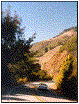
A road was built just to see this sight. Convicts and celebrated native sons like John Steinbeck built it. It strikes awe in each visitor. And, even though the road is environmentally damaging, it has roused a deep passion in the people who live around Big Sur and the Ventana Wilderness to protect it. Hwy One has come to define Big Sur. |
 |
 |
|
| As the remarkable beauty of Big Sur was revealed to the many by the road, so came the need to preserve it. | |
|
|
|
|
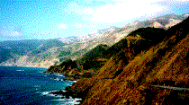
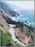
Hwy One by Partington. Photo by Stuart Stair. Click the picture for a larger version. |
|
|
Rosalind Sharpe Wall, as a young girl, lived in the Stone House in Rainbow Canyon, now known as Bixby, when the road was under construction. Her father dreamed of making millions from the tourists the road would bring. But Rosalnd hated it. |
“And when spring came, the canyon turned pink with blossoming wild currant and the mountains blue-violet with wild lilac. I sensed that the world I knew and loved would vanish from the coming of the highway. |
|
“I was 10 years old in 1929 when work on the highway started, and even though it was fun …I was unhappy to see the changes. I liked things the way they were. When Labor Day came and the tourists departed, I was relieved and joyous. We would go around and pick up the beer cans, soda bottles, candy papers and other litter that the traveling public left behind and once again things would return to normal. The singing birds — wild canaries, beautiful orange-winged orioles, purple finches — the barking of foxes, the howling of coyotes, even the scream of a bobcat. The people were gone and nature triumphed again. |
“When the highway was completed I refused to attend the ceremony of July 3, 1937, when Dr. John L. D. Roberts –whose dream the new scenic highway had been — cut the ribbon in front of our of our Stone House to allow the tourists to use the bridge for the first time. I didn’t even want to read newspaper accounts of the ceremony… “I would have nothing to do with the highway or the bridge that everyone was praising so highly. They said it was a miracle in concrete and steel suspension bridge in the world (also the highest) except for one in the south of France. I was blind to its beauty.” |
|
In spite of herself, Rosalind came to love the new Big Sur. In her mind’s eye she could heal the wounds made by the bulldozers. She realized that the new road kept people from using the old road, and that kept humans out of the back country. She wrote that the new road kept the Coast from intrusion, rather than the opposite. It was as though the remarkable beauty of Big Sur was exposed by the road, and with it was a human need to preserve its beauty. |
|
Today, visitors usually don’t realize it, but much of the scenic wonder of the Coast is accorded respect with a reverential lack of commercial signs. Wall wrote that her mother lobbied the board of supervisors and the county planning commission to keep out billboards, “hot dog stands, ..(and) flashy buildings along this undeniable spectacular highway.” |
|
She remembers the whole family traveling to Monterey to appear before the planning commission on preservation issues, “And my mother’s eloquent speeches on behalf of preserving the natural beauty of the highway won the day.” |
|
|
On his way to Henry Miller’s for dinner, Jack Keruoac passed out in a meadow in this canyon. His plan was to stay at Lawrence Ferlinghetti’s cabin in Bixby Canyon. He wanted to get away from booze. On the way he stopped in North Beach, imbibed to his usual excess, and hired a taxi to deposit him in Big Sur. Left along the old Coast Road, he ambled on his own into the canyon in the dark. He couldn’t find the cabin, and finally reposed in a meadow. Discovered in the morning, he stayed in Ferlinghetti’s for almost a week. Then, overcome by alcohol induced hallucinations, Keruoac declared the surf told him incessantly to leave and go write. Thus he wrote a book about Big Sur. |
|
|
|
a detour |
|
|
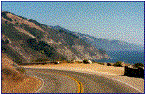
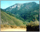
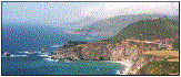
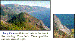
Big Sur Valley approached from the north. In this photo at left, Hwy One (lower right) speeds past Molera and into the redwood lined river valley. This is the only significant veer for Hwy One away from the coast. Old Coast Road (left foreground), the original road used before the highway was constructed, is now a ten mile rustic detour. Manuel Peak (also called Mount Manuel) looms over Pfeiffer Big Sur State Park, beyond Buzzard’s Roost. |
|
|
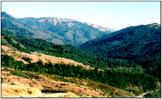
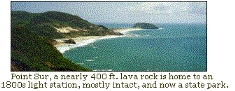
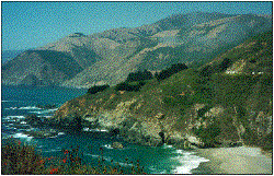
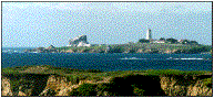
Point Sur, a dark volcanic cone, marks the most significant break along the whole Big Sur coast. It signifies the northern border of the Big Sur coastal scrub zone. Also, it is home to an historic lighthouse. Molera Point accentuates the only coastal flatlands along the whole coast. This is where the Big Sur River runs wild and free into the Pacific. |
|
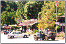 |
Along the whole coast route, there are only five spots where travelers find services in a little bunch. The first is near the River Inn, and in a little adjacent alcove. Then, a little south there is another mild commercial area at the Glen Oaks and Fernwood. The next one is at Loma Vista, where the post office is, near the entrance to Pfeiffer Big Sur State Park. Much farther down the road in Gorda there is gas. And, at Ragged Point near the southern extremity of Big Sur there is gas and convenient foods. |
|
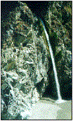
Huge pieces of granite, marble and sandstone are part of the complex geology of Big Sur. The granite cleanses the sea as it becomes crystal sand. Massive chunks of Big Sur came from at at least 3 disparate parts of Earth, and a vastly different times. Bold examples are seen clearly from Hwy One — as with McWay Creek where it falls onto the beach in Julia Pfeiffer Burns State Park. |
 |
A special breed settled Big Sur. Living in this beautiful place they developed a conservation mentality. Homesteaders in the southern reaches were confronted by William Randolph Hearst who wanted to add some of Big Sur to his Xanadu. He owned much of what is now Fort Hunter Liggett, including Mission San Antonio de Padua, and wanted to expand his holdings. The tycoon himself approached some land owners who weren’t willing to sell, and was met with the same resistance. Later, a group of prominent citizens, artists, including Ansel Adams, and politicians had designs on making Big Sur a National Park. But, that local conservation mentality raised up and convinced the well meaning politicians they could preserve the area better than park bureaucrats.
Big Sur Highway History and Issues
|
The Carmel – San Simeon Highway, as Highway One, and the Pacific Coast Highway,was originally known, was funded by a state bond in 1919, and completed in 1937. Throughout the construction, the highway was the source of disgruntlement, as much devastation was caused by the dynamiting and bulldozing. Great scars still persist from the massive project, and subsequent repairs. |
|
|
|
|
In the 80 years since the project began, great damage has occurred from landslides directly related to the road building or repair. Winter storms cause a lot of damage, too. Recent El Niño years, when more than 200 inches of rain from tropical storms precipitated erosion. The Highway has been closed several times for extended periods. In the winter of 1998-99, the road was closed virtually the whole winter of 1998-99. Historically, the state department of transportation has used ecologically unsound repair methods that exacerbate the problem. This has allowed the invasion of nonnative plants, like the Pampas Grass, that choke out native flora and weaken the soil. |
|
|
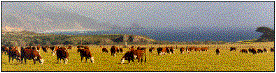
Cattle grazing, or, “ranching,” as some folks romanticize it, takes a severe toll on Big Sur watersheds. |
 |
|
|
Paul Henson and Donald J. Usner write in The Natural History of Big Sur : “Grazing cattle have worn distinct terraces and deep gullies into many hillsides. These terraces remain long after grazing is stopped and are familiar patterns on many hillsides above Highway 1 and in the backcountry. Grazing compacts the soil in some areas and accelerates erosion. When an area is overgrazed, the runoff from heavy rains forms small channels on the semi-denuded slopes. Subsequent rains deepen and widen the channels to form gullies and eventually larger arroyos. Small landslides and slips are also common on overgrazed slopes. |
|
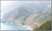
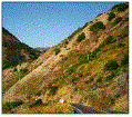
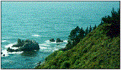
“Ranching has also been responsible for the introduction and proliferation of many nonnative species of grasses and weeds … several hardy and troublesome exotic weeds such as the milk thistle favor grazed areas. This weed is especially apparent in the heavily grazed area near Point Sur and Andrew Molera State Park.” (Above photo is of that area.) |
A report by John Smiley of the Big Creek Reserve is eloquently detailed and authoritative about the effects of the highway on Big Sur natural history. It contains a huge panoramic photograph of the complete area bounding Big Creek from the sea.
Big Creek Highway Issues
|
|
Reserve a Big Sur Lodge cottage at Pfeiffer Big Sur State Park online with Pelican Network. Go to Big Sur Lodge Guests receive the Guide to Big Sur |
|
Eco-Travel Guide to
California Central Coast Interactive
Map |
|