Blazing
a new coastal trail
Ambitious Mexico-to-Oregon path
faces plenty of hurdles
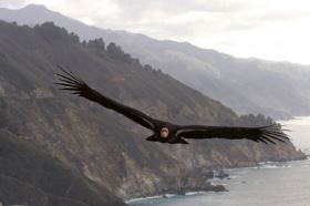
“Our task is to create a trail
that is our expression of how Big
Sur should be shared with the rest
of the world,” he said. “What we
care about is protecting our
ecosystems. We think this trail is
an opportunity to show the rest of
the world why Big Sur is so unique
and so worth protecting.”
By LAITH AGHA
Herald Staff Writer
Article Last Updated: 02/16/2008
01:31:01 AM PST
A trail is slowly being blazed
along the California coast from
Mexico to Oregon.
And now, the California Coastal
Trail &emdash; a route being created
for ambitious backpackers as well as
local hikers &emdash; is making its
way through Monterey County.
The coastal trail is being
created in a spirit similar to the
one that built the Pacific Crest
Trail, a 2,650-mile route that
connects Mexico to Canada while
passing through California, Oregon
and Washington, and the Appalachian
Trail, which stretches more than
2,000 miles from Georgia to
Maine.
“There’s quite a bit of
enthusiasm around it,” said Monterey
County Supervisor Dave Potter. “It’s
a great recreational
opportunity.”
The 1,200-mile coastal trail will
not be as long as the Pacific Crest
or Appalachian trails, but nailing
down the route through the state’s
more developed and more protected
coastal areas is a big challenge
that may take a long time.
Voters passed Proposition 20 in
1972 recommending a coastal trail
system be established and in 2001
state legislation called for the
trail’s completion, and the state is
now blazing its route through the
Central Coast.
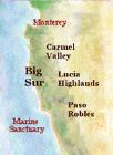
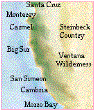
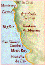
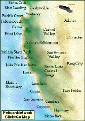
The county’s portion of the trail
is divided into two major sections:
the Big Sur Trail and the Monterey
Bay Sanctuary Trail.
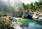
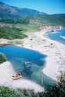
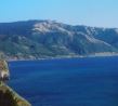
The Big Sur portion is about 75
miles long, from San Carporforo
Creek &emdash; near Ragged Point in
San Luis Obispo County &emdash; to
the Carmel River. A coalition of Big
Sur residents is doing the master
planning to ensure that the trail is
acceptable to the community.
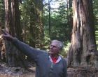
Jack Ellwanger is leading the Big
Sur residents committee for the
coastal trail.
“Our task is to create a trail
that is our expression of how Big
Sur should be shared with the rest
of the world,” he said. “What we
care about is protecting our
ecosystems. We think this trail is
an opportunity to show the rest of
the world why Big Sur is so unique
and so worth protecting.”
The Transportation Agency for
Monterey County is organizing the
20-mile portion of the trail around
Monterey Bay.
Currently there is no plan for a
trail section through Carmel and
Pebble Beach, said Tim Duff, a
project manager for the state
Coastal Conservancy.
The Pebble Beach Co. does not
have an official stance on the
prospect of the trail passing
through the privately owned Del
Monte Forest community, said Mark
Verbonich, company vice president of
community affairs.
“Nobody (company) has had any
contact about the California Coastal
Trail project,” Verbonich said,
adding that Pebble Beach allows
public access along 17-Mile Drive
for cyclists and pedestrians.
The Big Sur committee will work
with residents in six different
areas to craft particular sections
of the trail. It will have to work
with private property owners, but an
inclusive approach to the trail
planning should address their
concerns, Ellwanger said.
“We’re not proposing to take
anyone’s property,” Ellwanger said.
“This trail will be designed by the
people in (each area). If there’s
something they don’t like, we don’t
want to foist anything on them they
don’t want. They’re part of the
landscape, part of the community,
and this is a community-driven
process.”
The 7,000-acre El Sur Ranch is
one of the biggest pieces of private
property on the Big Sur coast. Owned
by Jim Hill, the ranch covers 11
square miles next to the Point Sur
Lighthouse.
Hill supports the trail, but
since Highway 1 and the Old Coast
Highway already pass through his
property, he is opposed to another
public route through the ranch, said
Aengus Jeffers, Hill’s attorney.
“The ranch is firmly opposed to
any effort to establish a new public
right-of-way through the ranch,”
Jeffers said in an e-mail.
Part of the coastal trail will
use existing paths, such as hiking
trails and segments of Highway 1 or
the Old Coast Highway, Potter
said.
The Coastal Conservancy does not
specify that the trail must be
within a certain distance of the
shore, just within “sight or
sound.”
“But that’s nebulous,” Ellwanger
said. He said the trail would go as
far inland as necessary.
So the trail could go around the
El Sur Ranch and other private
coastal property by veering inland
on already-established hiking
trails, Ellwanger said.
The entire coastal trail, which
is about half completed, remains a
long-term project.
“We’re looking at 20 to 30
years,” Duff said.
The county transportation agency
has a 15-year plan and a $27 million
cost estimate to complete its
segment along the bay. The Big Sur
section has no timetable.
“I don’t think you’re going to
see an end-to-end trail anytime in
the near future,” said Rep. Sam
Farr, D-Carmel, at a January meeting
in Big Sur. “The regulatory hassle
is unbelievable. It’s like we’re
building an interstate freeway.”
Laith Agha can be reached at
646-4358 or
lagha@montereyherald.com.